Explore the unique landscape of the Pinnacles Desert in Nambung National Park, one of Australia's most captivating destinations.
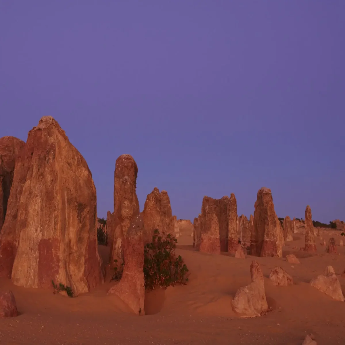
The natural limestone structures, with some reaching heights of up to 3.5 metres, were created around 25,000 to 30,000 years ago when the sea retreated and deposited shells.
The coastal winds gradually eroded the surrounding sand, exposing the pillars to the elements.
Nambung National Park features the stunning Pinnacles Desert, coastal dune systems, a heathland with diverse plant life, and picturesque beaches at Kangaroo Point and Hangover Bay.
Near the town of Cervantes at Lake Thetis at the park's northern end, there is a loop trail and boardwalk where visitors can observe stromatolites, rock-like structures formed by microscopic organisms.
Nambung National Park spans 174km² (67mi²) and is a natural habitat for various native animals and bird species.
Kangaroos and emus can often be seen during early mornings and late afternoons.
From August to October, the native vegetation displays a vibrant array of flowers, providing a memorable sight for visitors.
Common wildflowers found in late winter and spring include wattles, quandong, yellowtail flowers, thick-leaved fan flowers, white clematis, cockies tongues, parrot bush, and banksia species.
The Jurien Bay Marine Park features a beautiful offshore reef system, making it an ideal location for observing sea lions.
The Pinnacles Desert and Nambung National Park are situated near the coastal town of Cervantes, approximately 200km north of Perth, which is a two-hour drive away.
Pinnacles Desert Discovery Centre
Discover more information about the region by visiting the Pinnacles Desert Discovery Centre.
The displays, soundscapes, videos, and objects provide information on the geology of the pinnacle formations and the cultural and natural heritage of the area, including its flora and fauna.
The Pinnacles Desert Discovery Centre is in a low-heath area on the outskirts of the Pinnacles Desert.
The Pinnacles Desert Discovery Centre is open daily from 9:30 am to 4:30 pm, except on Christmas.
The building is designed with elements such as solar power, passive solar building design, and rainwater collection in mind, blending seamlessly with the surrounding environment. Adjacent is the Pinnacles View Lookout.
The Desert View Trail is a 1.5km (1 mi) walk that takes about 45 minutes round trip through the pinnacles. It starts at the Discovery Centre car park.
The Pinnacles Desert Lookout and Drive is a popular destination
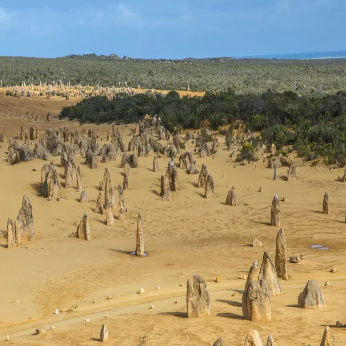
Visitors can explore the unique landscape of Australia's limestone pillars that rise from yellow sand, creating an intriguing sight.
Parking spaces are available along a one-way drive for visitors who want to stop and explore the Pinnacles Desert on foot.
Some pinnacles in certain areas can reach heights of up to 3.5m. They vary in shape, with some being jagged and sharp-edged columns that rise to a point, while others resemble tombstones.
Visible features in the Pinnacles provide clues to their origin, such as cross-bedding structures indicating abrupt changes in sand deposition from wind-formed dunes.
Certain pinnacles display a mushroom-like appearance, resulting from the presence of a calcrete capping. The mushroom shape results from the differential weathering rates between the harder capping and the softer limestone below it.
If you like this place, you can join an organised Pinnacles tour, which will give you an unforgettable lifetime experience.
Lake Thetis
For a unique experience, visit Lake Thetis (off Hansen Bay Road) to see stromatolites and stromatolites, some of the oldest living fossils on Earth that offer insights into ancient life.
Like the stromatolites in Hamelin Pool, the rock-like structures on the edge of Lake Thetis are formed by microscopic organisms invisible to the human eye. These structures host diverse communities with population densities of 3000 per square meter.
The stromatolite-building microorganisms in Lake Thetis closely resemble early life forms on Earth. The discovery of these modern examples has aided scientists in understanding the importance of microorganisms in the environment and uncovering the extensive history of life on Earth.
Currently, only a limited number of locations have living examples of these organisms that were once highly prevalent.
The Lake Thetis Loop Trail is a 1.5km (1 mi) return trail that follows the lake shore and offers opportunities to observe and learn about the communities and environment surrounding the lake. The initial 300 meters consist of an accessible boardwalk showcasing the best examples of stromatolites in the lake.
Kangaroo Point
This famous local beach offers views of Cervantes at Thirsty Point to the northwest and the Cervantes Islands within the Jurien Bay Marine Park.
Visitors can enjoy birdwatching opportunities at this location, with amenities such as barbecues, shelters, and restrooms available.
Hangover Bay
Hangover Bay features a wide sandy beach and opportunities for snorkelling, swimming, windsurfing, and surfing within Jurien Bay Marine Park waters.
Visitors should be on the lookout for bottlenose dolphins and sea lions. The local vegetation along the access road consists of summer-scented wattle, coastal banjine, and other common coastal species.
Bobtails, Gould's monitors, and carpet pythons, all harmless reptiles, can be observed at the facilities, which include barbecues, shelters, and toilets.
Jurien Bay Marine Park
Jurien Bay offers an extensive limestone reef system and a large shallow lagoon, making it an ideal habitat for Australian sea lions, dolphins, and juvenile fish.
Seagrass meadows within the reef provide a habitat for marine creatures, including western rock lobsters, octopus, and cuttlefish, which prey on young sea lions.
The marine park includes numerous ecologically important islands and is home to rare and endangered animals.
The marine park offers various water activities, including scuba diving, snorkelling, swimming, windsurfing, surfing, and fishing.
Bommies are 20 meters from Jurien Bay Town Beach, in the water, around eight meters deep. A snorkel trail is available for young visitors, and the area is suitable for night dives.
Boulanger Island, located near Island Point at the southern end of Jurien Bay, provides diving opportunities and sheltered anchorages. The island's western side features a seagrass meadow, ideal for snorkelling.
Fishing is allowed in most parts of the marine park, with restrictions on certain activities like spear-fishing and crabbing in specific areas. It is essential to be aware of the designated zones and regulations.
Jurien Bay Marine Park is 26km (16 mi) north of Cervantes.
The Turquoise Way Trail is a 14km fully-sealed trail that runs along the scenic coastline from Jurien Bay Marina to the Hill River Mouth, almost halfway to Cervantes. You can hire a bike or use your own to explore this route.
The Turquoise Way Trail offers a mainly flat terrain in the northern half, gradually becoming more undulating in the southern half. This trail is also suitable for walking, running, and jogging.
There are multiple access paths to the beach, some offering bike stands and shelters with picnic tables.
The trail includes the Dobbyn Park foreshore area, which features picnic spots, pavilions, public amenities such as toilets and drinking water fountains, beach access, playgrounds, an outdoor gym, outdoor shower, and is conveniently located near cafés, restaurants, and other town amenities in Jurien Bay.
Lesueur National Park
Lesueur National Park in Western Australia is a global biodiversity hotspot known for its significance in flora conservation.
The park comes alive with colour in late winter and spring as the diverse flora blooms, attracting wildflower enthusiasts.
Lesueur National Park covers an area of 9.8km² (3.8mi²) and is home to over 900 plant species, which account for 10 per cent of Western Australia's known flora.
Various types of orchids, such as pink enamel, purple enamel, cowslip, blue lady, white spider, and donkey orchids. Kangaroo paw varieties are also common during spring.
Carnaby's cockatoo is one of the 122 species of native birds found in the park. There are also 52 species of reptiles, with a particular abundance of geckos and legless lizards. Many of the reptiles in the park are at the outer limits of their range, similar to the plants and birds found there.
The park contains a range of landforms, including salt lakes, coastal dunes, laterite ridges, and flat-topped mesas like Mount Lesueur and Mount Michaud.
Visitors to the park can easily navigate by car or on foot. The Lesueur Scenic Drive offers stunning views of Mount Lesueur and Cockleshell Gully.
Various walking trails are available, including the Botanical Path, Gairdner Trail, the trail to Mount Lesueur, and Yued Ponar Trail.
Lesueur Scenic Drive is an 18.5km (11.5 mi) sealed road that loops around the park to and from Cockleshell Gully Road. It is delightful in spring, between August and November, when a wide variety of wildflowers bloom.
Lay-bys offer parking opportunities and access to various trails for exploring the scenery, including Mount Lesueur, Cockleshell Gully, and other bush areas.
Picnic benches and disabled-access toilets are available in a wooded area at the end of the Lesueur Scenic Drive.
Cockleshell Gully can be accessed via a short trail, with the first few hundred meters wheelchair-accessible.
The Yued Ponar Trail is an 8km loop above the Cockleshell Gully Picnic area, offering a varied landscape. It is recommended to have a good level of fitness and bushwalking experience to complete the circuit in 3 to 4 hours.
The trail ascends gradually, with occasional steep sections, before tracing along the plateau towards Mount Peron. A brief side trail takes you to the summit, offering panoramic views of the Indian Ocean and the park's interior towards Mount Lesueur.
The trail extends 600m to the Kada Boodja lookout before circling back to the valley floor.
The Yued Ponar Trail winds through various landscapes in the park, showcasing multiple plant life. Along the trail, visitors can learn about the traditional culture and resources of the Yued Noongar people.
Drummond's parking area provides a convenient spot for admiring scenic views and accessing trails that venture further into the surrounding bush.
The Botanical Path is a 400-meter trail that starts at the Drummond car park and leads to the Iain Wilson Lookout. It is wheelchair and pram accessible, with interpretive signs providing information on the park's 900 plant species.
The Mount Lesueur Trail is a 4km (2.4 mi) return trail that starts after following the Botanical Path for 250m. The trail leads to the almost flat-topped Mount Lesueur, with a flat first kilometre before a steeper rocky section.
The summit offers spectacular views to the south, east, and west and typically takes 1 to 2 hours to reach.
Please ensure you use the scrubbing station before starting your walk.
The Gairdner Trail is a 2.5km loop trail from the Drummond car park. It follows the Botanical Path for the first 250m before passing through Kwongan heath and the low woodlands of Wandoo to the sandstone outcrops of Gairdner Ridge. It typically takes 1 to 1.5 hours to complete.
Hikers can combine the Lesueur and Gardner trails by following the heathland path up to Mt. Lesueur on the Lesueur Trail and then completing the loop around the Gardner Trail. This walk offers a spectacular view of wildflowers throughout the route.
Lesueur National Park is situated 27km northeast of Jurien Bay and 250 km north of Perth on the Brand Highway. Access is from Cockleshell Gully Road, which is unsealed but has a suitable surface for two-wheel drive vehicles.
Lesueur National Park is not heavily affected by the soil-borne plant pathogen dieback. Boot cleaning stations are available for visitors to use on bushwalking trails. Staying on marked roads and trails while exploring the park is essential. There are no camping facilities or drinking water within the park, and entry fees are required.
Accommodation options in Cervantes and Jurien Bay
Camping is not permitted in Nambung National Park. However, various accommodation choices are available in the nearby towns of Cervantes and Jurien Bay.
Jurien Bay Motel Apartments
Located at 7 Murray St in the town of Jurien Bay.
They have a rating of 4.5 stars.
Prices start from AUD181 per night.
The apartments are just a short walk from the beach and the town centre. The complex offers 21 fully self-contained apartments, including two-bedroom, one-bedroom and studio options with limited kitchen facilities. Amenities include air conditioning, a flat-screen TV, a Foxtel TV channel and Wi-Fi.
Pinnacles Edge Resort
Located at 7 Aragon St, Cervantes
3.5 star rating.
Rates start from AUD145 per night.
The resort offers deluxe accommodations, including studios and spa suites. It is centrally located in the heart of Cervantes, close to shops, the beach and the visitor centre. The resort is just a 15-minute drive from the Pinnacle Desert. Guests can also visit the Europa Anchor Restaurant, which is located in the same building as the Cervantes Pinnacles Motel.
Consider visiting Nambung National Park at the optimal time
The park is worth visiting year-round and is a convenient day trip from Perth.
For those who appreciate nature, the optimal time to visit Nambung National Park is September and October, when the wildflowers are in bloom and the vistas of wattles extend across the horizon.
The average seasonal temperatures for Cervantes and Jurien Bay range from around 30°C (86°F) in December to February, 26°C (78°F) in March to May, 20°C (68°F) in June to August, and 23°C (73°F) in September to November.
Getting there
The Pinnacles Desert and Nambung National Park are approximately 200km north of Perth, about a two-hour drive.
Nambung National Park can be easily reached by car by travelling north from Perth on Wanneroo Road-Indian Ocean Drive, which leads directly to the park. The road into the Pinnacles Desert is paved.
To reach the Pinnacles, drive north on the Brand Highway and make a left at the sign for Cervantes. The car park is approximately 16km (10 mi) from Cervantes.
Cervantes is approximately 220km (136 mi) south of Geraldton, accessible via the Brand Highway and Indian Ocean Drive.